


A UAV-USV Collaborative Water Depth Inversion Model Based on Multi-Modal Heterogeneous Sensors
-
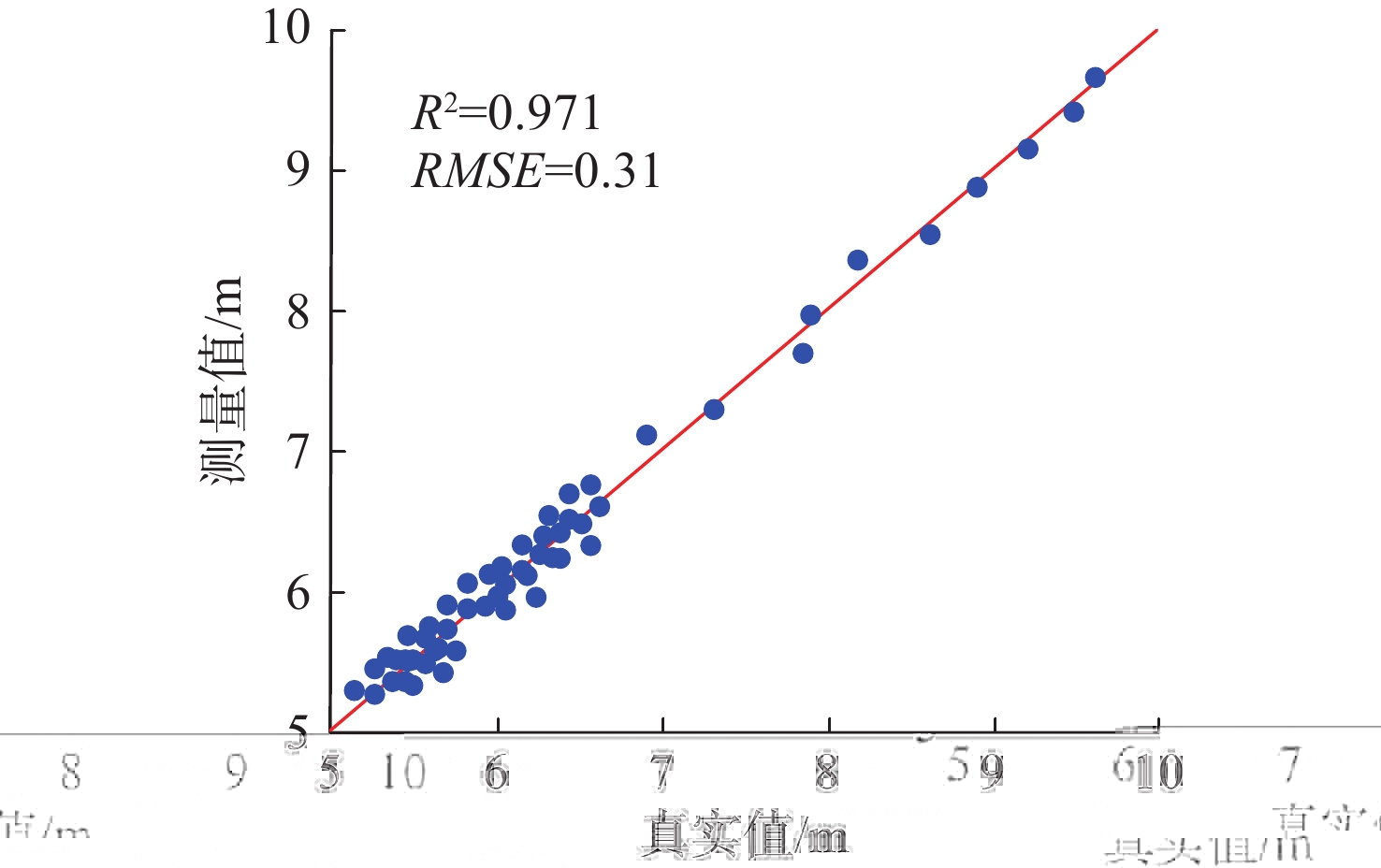
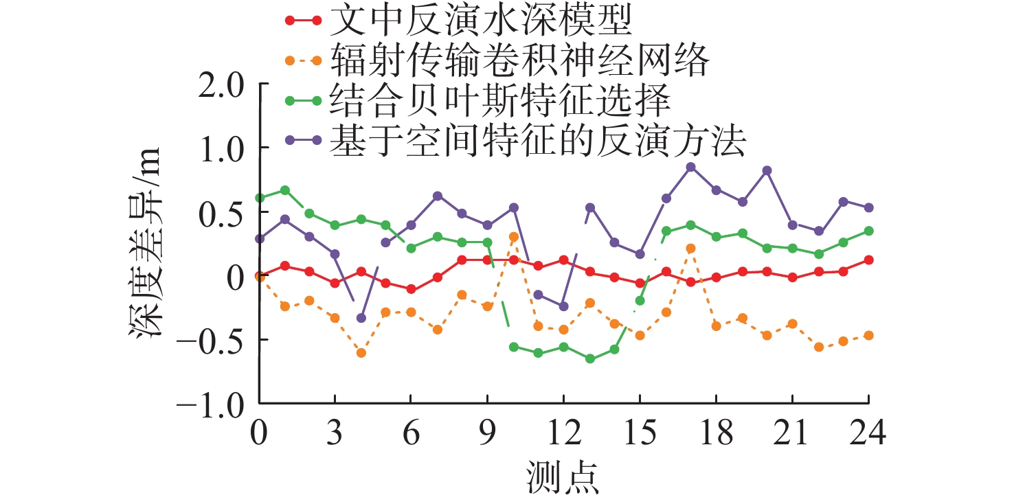
摘要: 针对复杂水域环境单一遥感平台或同构数据的水深反演精度低问题, 文中提出一种基于多模态异构传感器的无人机-无人船协同水深反演模型。该模型先通过多光谱指数联合提取目标水体, 再融合双平台多模态传感器数据, 利用梯度提升决策树(GBDT)挖掘非线性映射关系以反演水深。实验表明, 模型决定系数达0.971, 均方根误差为0.31 m, 水深波动控制在±0.2 m内, 精度显著优于传统对比方法。Abstract: In response to the low accuracy of water depth inversion in complex water environments using a single remote sensing platform or homogeneous data, this paper proposes a collaborative water depth inversion model between unmanned aerial vehicles and unmanned ships based on multimodal heterogeneous sensors. The model first extracts the target water body through multi spectral index joint extraction, and then integrates dual platform multimodal sensor data. It uses gradient boosting decision tree (GBDT) to mine nonlinear mapping relationships and invert water depth. The experiment shows that the model has a coefficient of determination of 0.971, a root mean square error of 0.31 m, and the water depth fluctuation is controlled within ± 0.2 m. The accuracy is significantly better than traditional comparison methods.
-
表 1 遥感数据参数表
Table 1. Table of remote sensing data parameters
类型 范围/μm 分辨率/m 蓝 0.45~0.52 2.44 绿 0.52~0.60 2.44 红 0.63~0.69 2.44 近红外 0.76~0.90 2.44  下载: 导出CSV
-
[1] 郭松涛, 邢帅, 张国平, 等. 异构卫星遥感数据融合的水深反演模型[J]. 测绘通报, 2024(5): 19-23. doi: 10.13474/j.cnki.11-2246.2024.0504Guo S T, Xing S, Zhang G P, et al. Bathymetric inversion model for fusion of heterogeneous satellite remote sensing data[J]. Bulletin of Surveying and Mapping, 2024(5): 19-23. doi: 10.13474/j.cnki.11-2246.2024.0504 [2] 许永刚, 孙世军, 朱坤双, 韩 洪, 王明军. 基于改进决策树的短期风速预测算法设计[J]. 电子设计工程, 2024, 32(11): 82-86. doi: 10.14022/j.issn1674-6236.2024.11.017Xu Y G, Sun S J, Zhu K S, Han H, Wang M J. Design of short-term wind speed prediction algorithm based on improved decision tree[J]. Electronic Design Engineering, 2024, 32(11): 82-86. doi: 10.14022/j.issn1674-6236.2024.11.017 [3] 谢丛霜, 陈鹏, 潘德炉. 主被动遥感融合辐射传输卷积神经网络水深反演方法[J]. 光子学报, 2024, 53(8): 46-58. doi: 10.3788/gzxb20245308.0801002Xie C S, Chen P, Pan D L. Bathymetric inversion method for active-passive remote sensing fused radiative transfer information convolutional neural networks[J]. Acta Photonica Sinica, 2024, 53(8): 46-58. doi: 10.3788/gzxb20245308.0801002 [4] 蓝歆玫, 李佳, 叶杨, 等. 结合贝叶斯特征选择的近海水深反演方法研究[J]. 海洋通报, 2024, 43(4): 463-470. doi: 10.11840/j.issn.1001-6392.2024.04.003Lan X M, Li J, Ye Y, et al. Research on inshore depth inversion method combined with Bayesian feature selection[J]. Marine Science Bulletin, 2024, 43(4): 463-470. doi: 10.11840/j.issn.1001-6392.2024.04.003 [5] 孟鑫垚, 刘焱雄, 陈义兰, 等. 基于空间特征的机器学习模型浅海水深反演[J]. 海洋科学进展, 2023, 41(3): 498-509. doi: 10.12362/j.issn.1671-6647.20220813001Meng X Y, Liu Y X, Chen Y L, et al. Spatial feature-based machine learning model for shallow water depth retrieval[J]. Advances in Marine Science, 2023, 41(3): 498-509. doi: 10.12362/j.issn.1671-6647.20220813001 [6] 高二涛, 周国清, 李佶洋, 等. 顾及地理位置特征的近海水深遥感反演方法[J]. 遥感学报, 2025, 29(8): 2559-2574. doi: 10.11834/jrs.20243537Gao E T, Zhou G Q, Li J Y, et al. Remote sensing inversion method for offshore water depth considering geographical location characteristics[J]. NATIONAL REMOTE SENSING BULLETIN, 2025, 29(8): 2559-2574. doi: 10.11834/jrs.20243537 [7] 王照翻, 马梓程, 熊忠招, 等. 多光谱遥感数据与多类型机器学习算法的浅海水深反演方法评价[J]. 热带地理, 2023, 43(9): 1689-1700. doi: 10.13284/j.cnki.rddl.003742Wang Z F, Ma Z C, Xiong Z Z, et al. Assessment of multi-spectral imagery and machine learning algorithms for shallow water bathymetry[J]. Tropical Geography, 2023, 43(9): 1689-1700. doi: 10.13284/j.cnki.rddl.003742 [8] 黄茂苗, 魏永亮, 唐泽艳, 等. 基于梯度提升决策树模型的Sentinel-1图像浅海水深反演[J]. 海洋科学, 2024, 48(4): 1-17. doi: 10.11759/hykx20221121001Huang M M, Wei Y L, Tang Z Y, et al. Retrieval of shallow water depths from Sentinel-1 images based on a gradient boosting decision tree model[J]. Marine Sciences, 2024, 48(4): 1-17. doi: 10.11759/hykx20221121001 [9] 孟然, 沈蔚, 栾奎峰, 等. 基于梯度提升决策树算法的水深反演研究[J]. 海洋湖沼通报, 2023, 45(1): 45-50. doi: 10.13984/j.cnki.cn37-1141.2023.01.007Meng R, Shen W, Luan K F, et al. Water depth retrieval based on gradient boosting decision tree algorithm[J]. Transactions of Oceanology and Limnology, 2023, 45(1): 45-50. doi: 10.13984/j.cnki.cn37-1141.2023.01.007 [10] 曾书玉, 谢涛, 孔瑞瑶. 基于CatBoost和XGBoost组合模型的水深反演[J]. 海洋测绘, 2023, 43(3): 59-63.Zeng S Y, Xie T, Kong R Y. Water depth inversion based on CatBoost-XGBoost combined model[J]. Hydrographic Surveying and Charting, 2023, 43(3): 59-63. [11] 衣天龙, 邵琦, 李秋元. 基于优化覆盖算法的异构多模态信息检索方法[J]. 计算机仿真, 2024, 41(10): 493-496,506. doi: 10.3969/j.issn.1006-9348.2024.10.094Yi T L, Shao Q, Li Q Y. Heterogeneous multimodal information retrieval method based on optimal coverage algorithm[J]. Computer Simulation, 2024, 41(10): 493-496,506. doi: 10.3969/j.issn.1006-9348.2024.10.094 [12] 侍恒, 曾贺, 苏磊, 等. 基于区域生长法的无人机和无人船一体化测绘技术研究[J]. 人民黄河, 2024, 46(11): 137-141,148.Shi H, Zeng H, Su L, et al. Research on integrated surveying technology of unmanned aerial vehicles and unmanned boats based on the region-growing method[J]. Yellow River, 2024, 46(11): 137-141,148. [13] 刘超群, 卢自来, 刘敏, 等. 基于无人机和无人船的河(江)道地形测绘技术应用[J]. 水运工程, 2023(S1): 138-142. doi: 10.3969/j.issn.1002-4972.2023.z1.027Liu C Q, Lu Z L, Liu M, et al. Application of river channel topography mapping technology based on UAVs and unmanned ships[J]. Port & Waterway Engineering, 2023(S1): 138-142. doi: 10.3969/j.issn.1002-4972.2023.z1.027 [14] 王燕茹, 张利勇, 刘文, 等. 基于高空间分辨率遥感影像的水深反演有效性评估[J]. 海洋学报, 2023, 45(3): 136-146.Wang Y R, Zhang L Y, Liu W, et al. Evaluation of validity of bathymetry retrieval data based on high-spatial resolution remote sensing image[J]. Journal of Oceanography, 2023, 45(3): 136-146. -

 下载:
下载:

 点击查看大图
计量
- 文章访问数: 182
- HTML全文浏览量: 83
- PDF下载量: 0
- 被引次数: 0
图(8) / 表(1)